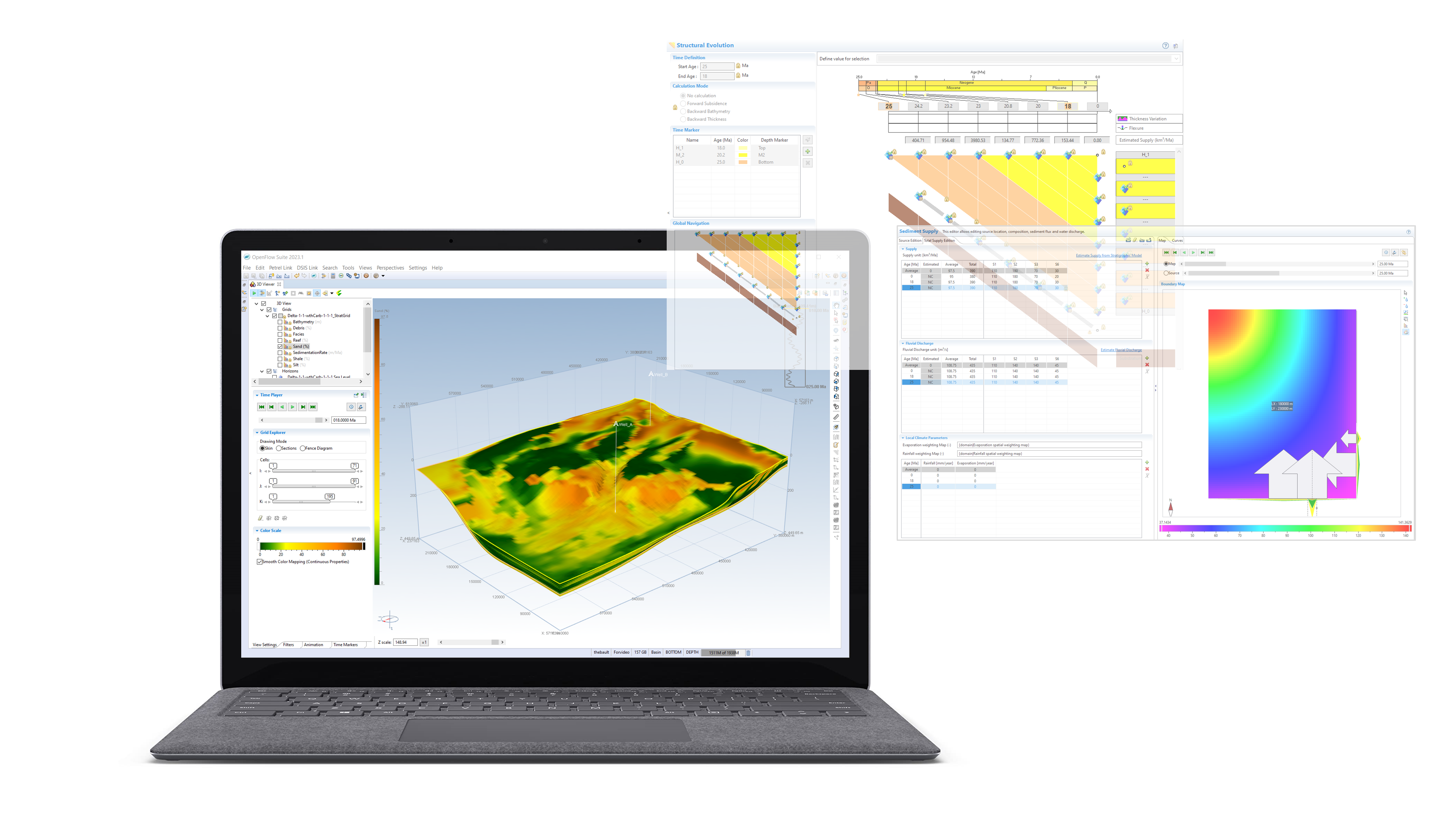
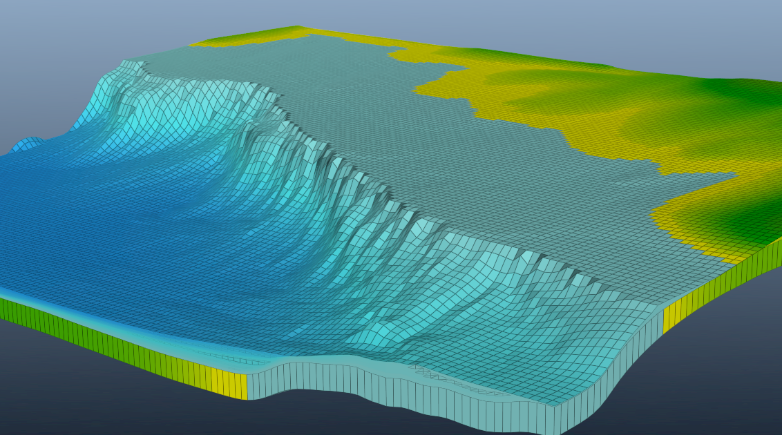
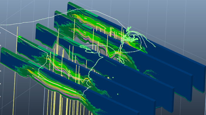
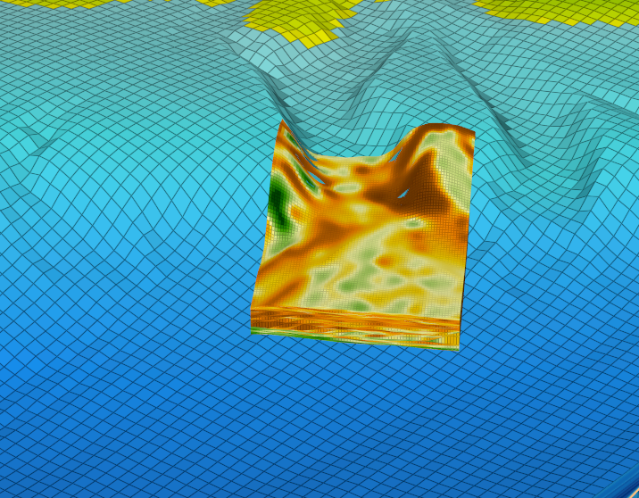
+

Software

State-of-the-art technology on E&P Software Solutions.

OpenFlow suite from exploration to reservoir management : New generation geoscience software for successful exploration and development of conventional and non-conventional O&G.

Home
 

Share

.
.
.
.

Search form

  • About us
    • Our company
    • Our Values and Mission
    • Our international presence
    • Governance
  • Our Solutions
    • Exploration
      • Regional evaluation
      • Offshore / Deep offshore
      • Compressive basins
      • Mature basins
      • Non conventional
      • Our methodology and proprietary technology portfolio
        • Seismic Reservoir Characterization
        • Basin modeling and Petroleum System Analysis
        • Stratigraphic modeling
      • Promotion studies, Advice to Ministries and Agencies
    • Field Development
      • Integrated field studies
      • Master Development Plan
      • Enhanced Oil Recovery
        • Prefeasibility studies
        • Integrated EOR feasibility studies up to pilot design
        • Pilot implementation and monitoring
      • From seismic attributes to rock properties
      • Carbonate fields
      • Fractured fields
      • Giant fields
    • Reserves evaluation, certification, unitization
    • Energy transition and Carbon Management
    • E&P Economics and Contracts
    • Downstream process
    • Unconventional Resources
  • consulting
    • Our offer
    • Our methodology
    • Our references
  • Software
    • Our Solutions
      • DionisosFlow
      • CougarFlow
      • EasyTrace
      • FracaFlow
      • InterWell
      • KronosFlow
      • PumaFlow
      • TemisFlow
      • TightFlow
    • Latest Release
      • OpenFlow Suite 2022
      • EasyTrace 2021
      • InterWell 2021
      • Download software
    • Our services
      • Support
      • Training
      • Technical assistance
      • Custom Software Development
      • Cloud
    • Our Academic Program
  • Media Center
    • Events
      • Archives
    • News
    • Publications
    • Download
  • Careers
    • Working for Beicip-Franlab
    • Job Opportunities
    • Unsolicited applications
  • Contact us

You are here

  1. Home
  2. Software
  3. Our Solutions
  4. DionisosFlow
Share
Send
Print
Our Solutions

DionisosFlow

Stratigraphic modeling 
Aiming at de-risking exploration by predicting stratigraphy and facies architecture in unexplored areas, DionisosFlow® reconstructs facies architecture through geological time at basin or appraisal scale while honoring sequence stratigraphy models based on core, well logs and seismic data.
 
 
Predicting stratigraphy at regional scale for reducing the exploration risk

DionisosFlow® is a unique industrial package for generating 4D forward stratigraphic models in under-explored areas while assessing the complex interaction between accommodation space, sediment supply and transport through a combined simulation of sedimentary processes (continental to marine siliciclastics, carbonates). DionisosFlow® helps in delimiting:

  • geometry and facies of reservoirs bodies;

  • extension and thicknesses of seals;

  • distribution and nature of source rocks;

  • paleo-geometries of sedimentary basins.

A physically sound geo-history of sedimentary basin development including sedimentary architecture, lithological facies and paleo-bathymetry distribution through space and time is delivered.
DionisosFlow® has been validated successfully through numerous case studies including amongst others, the Middle-East Cretaceous carbonate platform, Gulf of Mexico salt-driven tectonics province, Niger delta turbiditic system and the intra-cratonic depression in North Africa.

DionisosFlow® has also been applied favorably for delineating subtle stratigraphic traps in mature basins.

Modeling sedimentary processes

Accounting for subsidence rate, eustasy and sediment supply, DionisosFlow® simulates sediment erosion, transport and deposition as well as local carbonate production. Carbonate production is modeled using bathymetry, wave/drift energies and ecological controlling factors.

Sediment transport is controlled by combining river discharge and slope parameters as well as flooding and slope instability for catastrophic sedimentary processes.
Input data consists in up-to-date interpreted depth maps, subsidence maps, sea level variation data and salt deformation, if applicable.
Calibration is made against seismic facies and hard log data (NTG curves, Vshale, Gamma Ray, Resistivity).
 

Key benefits 
  • Applicable in clastic, carbonate and mixed environments, from continental to deep water 

  • Tailored for stratigraphers and sedimentologists

  • Seamless link with TemisFlowTM for further multi-dimensional basin modeling

  • Slick & user-friendly


  • Uncertainty and risk analysis

  • Compatible with third-party applications ( such as MPath® and Of-Mod®),

  • Innovation through active research & development


Previous Pause Next
Simulated 3D block showing the facies distribution. Vertical exaggeration x10.

+

Simulated 3D block showing the facies distribution. Vertical exaggeration x10.
Nova Scotia Margin: Sand distribution and calibration to well data.

+

Nova Scotia Margin: Sand distribution and calibration to well data.
Facies definition in DionisosFlow from simulated properties. Environmental parameters are used to generate facies information, for instance bathymetry, wave energy, slope, sediment proportions.

+

Facies definition in DionisosFlow from simulated properties. Environmental parameters are used to generate facies information, for instance bathymetry, wave energy, slope, sediment proportions.
Analysis of silty turbidites distribution within a given sequence: NTG (left) and total thickness in meter (right).

+

Analysis of silty turbidites distribution within a given sequence: NTG (left) and total thickness in meter (right).
Typical output of a multi-realization workflow linking DionisosFlow with CourgarFlow for sensitivity and risk analysis. This map shows the degree of variation of multiple simulations, all calibrated to well data, in terms of sediment texture (less changes from a simulation to the other in green, more changes in red). This type of workflow allows quantifying the risk associated to the model such as facies prediction or thicknesses.

+

Typical output of a multi-realization workflow linking DionisosFlow with CourgarFlow for sensitivity and risk analysis. This map shows the degree of variation of multiple simulations, all calibrated to well data, in terms of sediment texture (less changes from a simulation to the other in green, more changes in red). This type of workflow allows quantifying the risk associated to the model such as facies prediction or thicknesses.
Clinoform serie in Western Siberia. Vertical exaggeration x60.

+

Clinoform serie in Western Siberia. Vertical exaggeration x60.
Carbonate atoll growth. Vertical exaggeration x100.

+

Carbonate atoll growth. Vertical exaggeration x100.
Facies model (left) and focus on basin floor fans and turbiditic channels (right).

+

Facies model (left) and focus on basin floor fans and turbiditic channels (right).
Our solutions & Download
DionisosFlow - TechnicalSpecifications
DionisosFlow - ProductSheet
Our solutions
Stratigraphic Modeling
Regional Evaluation
  • Our Solutions
    • DionisosFlow
    • CougarFlow
    • EasyTrace
    • FracaFlow
    • InterWell
    • KronosFlow
    • PumaFlow
    • TemisFlow
    • TightFlow
  • Latest Release
  • Our services
  • Our Academic Program

Careers

Internship in Python Programming applied to Reservoir Engineering
RP-2022-03
Specialist in geoscience software
2023-Geoscience-Software

More Informations

  • Site map
  • Legal notice
  • Contact us